Challenges
Geogrupa d.o.o. has recognized the possibility of using artificial intelligence to identify and update data on traffic signs and public lighting poles. The mapping of these infrastructure elements has traditionally relied on field visits, manual records and data transmission, which has been a lengthy work, often resulting in uneven accuracy and increased operational costs. Given the growing demand for more accurate and faster management of municipal infrastructure, there was a need to improve and digitize this process with the aim of reducing the time needed to perform these activities, and reducing the cost.
Solution
Through the ‘Test Before Invest’ (TBI) service and with the professional support of the EDIH Adria consortium, Geogroup tested the potential of using artificial intelligence (AI) and computer vision models to address these problems. The aim was to test whether AI and computer vision models can be applied in order to automate and digitize the process of locating infrastructure elements with the aim of relieving employees and speeding up the process.
As part of the TBI activity, AI machine learning models were tested for the detection of communal infrastructure elements:
- Traffic sign detection: Using models based on YOLO (You Only Look Once) architecture, a prototype system for automatic recognition and classification of traffic signs from street scene images was developed. The system enables fast and precise marking of signs in space, with the additional possibility of categorizing identified traffic signs (e.g. stop, right of advantage, dead end, etc.). The main goal was to automate the process of identifying the coordinates of traffic signs and their categorization and cataloguing.
- Detection of public lighting poles: In the same technological framework, an approach for the identification of public lighting poles has been tested. Models were trained on a representative sample of data from a dozen shots of street scenes made by a rectangular camera with data on camera coordinates and direction of movement, using manually marked examples as a basis for training and validation of the model.
The system prototype, developed as part of the project, enables the visualization of detections through a simple and clear user interface created using Streamlit and Leaflet OpenStreetMap mapping tools. The system has shown high precision at the test set, and the results suggest a clear potential for integration into existing infrastructure detection processes in public areas or as a potential for offering additional services organized by Geogrupa d.o.o .

Figure 1 – Display of interactive map with detected traffic signs and public lighting poles

Figure 2 – Table of object detections with information on coordinates, class and number of images on the basis of which coordinates were calculated

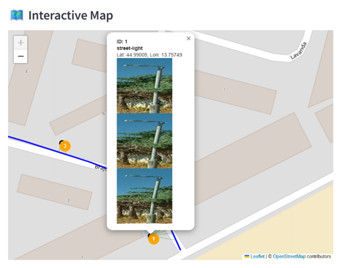
Figure 3 – Illustration of details of up to three images excluded from the videos on the basis of which object coordinates were calculated
Results and Benefits
Testing conducted as part of TBI activities has shown great potential for the application of AI technologies in the processing of street imagery and the management of infrastructure elements, enabling:
- Increased efficiency: Automated detection of traffic signs and public lighting poles significantly accelerates the processing of large amounts of field shots, thus reducing the need for manual inspection and marking.
- Improved accuracy and consistency: AI models such as YOLO provide a high level of precision in object recognition and classification, with greater consistency than is possible with a manual approach.
- Better resource allocation: By replacing manual processes with automatic analysis, employees can focus on other tasks.
- Scalability and possibility of extension: The system can be easily customised to detect additional objects or customised to integrate with other applications and/or connect to existing or open source databases such as PostgreSQL.
Lessons learned
During the TBI phase of system development and testing, key findings for successful implementation were identified:
- Quality and diversity of input data: Detection success largely depends on the quality of the shots and the variety of examples in the training set – e.g. different weather conditions, character types, shooting angles.
- Adapting the model to the local context: For precise classification, it was necessary to adapt the models to the specificities of local signalling and infrastructure, which includes the use of domestic data for model training.
- Visual interpretation of the results: The intuitive user interface (made in Streamlit) made it easier for users to view and understand the results without technical pre-knowledge.
Estimated effects of implementation
Based on testing prototypes and analyzing existing methods of processing street image data, it is estimated that the full implementation of AI systems for the detection of traffic signs and public lighting pillars could significantly improve the company's operational processes. By automating detection, it would significantly reduce the time needed to analyze the collected material, thereby increasing the speed of delivery of services to end users.
Reducing the need for manual tagging and validation of data would have a direct impact on reducing the operational cost and administrative burden for employees. This would allow employees to devote more time to more complex tasks.
In addition, greater precision and consistency in the detection of transport infrastructure reduces the possibility of gaps, providing end-users – such as cities, utilities and administrations – with more accurate information for decision-making and the planning of interventions. The system also opens up the possibility to further develop complementary functionalities, such as automatically generating reports or tracking changes over time, which further increases the value of the services offered.
Conclusion
The ‘Test Before Invest’ project carried out at Geogrupa d.o.o. has successfully demonstrated that the use of artificial intelligence to automate and improve the process of detecting traffic signs and public lighting poles is a very powerful solution and that the full implementation of such a solution in the organisation should certainly be considered. Acquired insights and developed prototype models provide a solid basis for making informed decisions about procurement and implementation of complete commercial solutions. EDIH Adria continues to support Geogroup and other SMEs as well as local self-government units (LGUs) in their digital transformation efforts, helping them to take advantage of advanced technologies for more efficient, transparent and sustainable management of their business, and SME segment organizations and comparative advantage in the domestic and foreign markets.